[Post under construction]
😶

Graham Hancock is not very keen on making firm inferences from this "looks like" and "just asking questions" approach to prehistory. That however just leaves his ideas in the realms of general speculation. It might be instructive to take his premises (which it has to be said do tend to shift depending on the occasion) and see where thet lead us. Let us just do a bit of modelling based on accepting for the sake of the argument the following premises and without trying to delve so deeply into the specialist literature:
1) In the deep past in the period before the Holocene and Anthropocene, there are a lost advanced civilization - as proposed by various writers of the genre including Hapgood and Hancock.
2) They were advanced enough to be seafarers (Hapgood and Hancock)
3) They were able to conduct astronomical observation [assumption repetitively over many years from fixed points "observatories"] over a length of time to untangle complex astronomical sequences and progressions and apply that knowledge to the alignment of monuments (Hancock) and navigate (Hapgood)
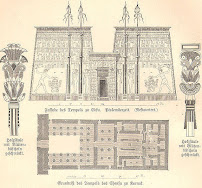
drawing of the Ptolemaicperiod temple at Edfu
The Edfu Texts
In Magicians of the Gods, on @JoeRogan, and other podcasts, Graham claims the Edfu texts are an Egyptian version of the Atlantis myth found in Plato. There are many problems with this conclusion that he doesn't share.
- They were carved over a century after Plato died. Plato died in 348 BCE. They were carved on a temple built in Egypt when Egypt was ruled by the Greek speaking Macedonian, Ptolemy III. Plato's
 |
| Benben bird |
ATLANTIS IN THE MEMORY OF ANCIENT EGYPT. This dynamite investigation by Manu Seyfzadeh is published for the first time on my website.Well, if the text was intended as an academic presentation of evidence in the field, the writing style is atrocious.
Archaeology with Flint Dibble:
The Archaeology of Rapa Nui (Easter Island) with Dr. Dale Simpson, Jr.
Chapters: 3:08. Rapa Nui 101. Introduction to island and archaeology 14:28. The scale of scholarship and study on the island 19:08. The problematic myth of "Collapse." 23:40. Moving the Moai 30:29. The red stone: pukao 33:27. The basalt. 43:22. Mines, quarries, and other stones 48:14. Conclusion: the geologists of their time Keywords: archaeology, history, prehistory, geology, Easter Island, Rapa Nui, lithics, stone working, statues, geoarchaeology, PolynesiaWell worth watching.
Dan Richards The DeDunker
@DeDunkingPast
Jul 15 "So if you shrink it, distort it to fit a modern map projection, turn it upside down... this map shows Antartica without the ice !!!" This is a really dubious claim. The map Noua, et integra vniuersi orbis descriptio (1532) by Oronce Fine [1494-1555] was originally published in the volume by Johann Huttich and Simon Grynaeus Novus orbis regionum (Paris. 1532). Here's a description from the website of the Norman B. Leventhal Map and Education Center Collection Boston Public Libraries:
Fine, an eminent French cartographer, created this unique double cordiform or heart-shaped projection, emphasizing the northern and southern hemispheres. The European, Asian and African continents were prominently placed in the center of the left (northern) cordum. However, his treatment of the Americas was somewhat more tentative. By splitting the new World discoveries along the left edge of the northern cordum, it was not obvious that he had depicted these lands as a large peninsula attached to the Asian mainland. While this depiction contradicted Waldseemüller's model, Fine did retain the name America, which appears in the southern part of South America, in the right (southern) cordum. This portion of the map is dominated by a continent that was still speculative. Fine labeled it, "Terra Australis," based on Magellan's relatively recent passage through the strait at the southern tip of South America. A modern redrawing on an oval projection (see below) by Robert W. Karrow helps to clarify the geographic images portrayed on Fine's map. Fine's use of a single cordiform projection in 1519, as well as this use of the double cordiform projection, introduced a tradition of similar world maps throughout the 16th century. While the projection has a mathematical basis, it presents a visually pleasing map. It is also conceivable, since the heart was a widespread Christian symbol, that the use of the heart-shaped projection added religious meaning to the contents of the map.[here's a zoomable colour version in the Library of Congress].

Luke Caverns @lukecaverns · Jul 15"an ancient land" - as if there was nothing in his native Texas before the white landgrab. In his local museum, are the Native American cultures housed in the Natural History museum alongside the butterflies and stuffed birds like one I saw in Florida? To me, that's a telling attitude.
Good to be back in an ancient land. The Zapotec world is incredible.